Creek
Northern terminus and Green Line interchange in Al Jaddaf, linking the Blue Line to Deira, Bur Dubai, and the Creek districts.
Green Line
Under construction · Opens 2029
Dubai Metro Network
Dubai's third metro line: a 30 km Y-shaped route with 14 planned stations linking Dubai Creek Harbour, International City, Dubai Silicon Oasis, and Academic City to the Red and Green Lines, targeted to open on 9 September 2029 and already mapped on the Dubai Map.
Planned opening
2029
Targeted for 9 September 2029, the metro's 20th anniversary.
Stations
14
9 elevated and 5 underground across two branches.
Line length
~30 km
About 15.5 km underground and 14.5 km elevated.
Daily ridership
200,000
Projected for 2030, rising to 320,000 by 2040.
Timeline
First envisioned in the early planning of Dubai's rail network and formally approved in 2023, the Blue Line is the metro's third line and its first major eastern expansion, now under construction toward a 2029 opening.
24 November 2023
Project approved
His Highness Sheikh Mohammed bin Rashid Al Maktoum approves the Blue Line as part of the Dubai 2040 Urban Master Plan, adding a 30 km line to the metro network.
2025
Construction begins
Main works start under the RTA across elevated sections, underground corridors, and 14 station sites, delivered under a construction contract awarded to the MAPA, LIMAK, and CRRC consortium.
November 2025
Construction reaches 10 percent
The RTA reports the project on schedule at roughly 10 percent complete within its first five months, with about 30 percent targeted by the end of 2026.
May 2026
Tunnelling begins
Underground tunnelling is inaugurated using a large tunnel boring machine, marking the start of the line's deep-bored sections beneath eastern Dubai.
9 September 2029
Planned opening
The Blue Line is targeted to open, interchanging with the Green Line at Creek and the Red Line at Centrepoint to complete a three-line network.
Key Figures
The essential figures behind Dubai's next metro line, from route length and configuration to capacity, investment, and the communities it will connect.
Route configuration
Y-shaped, two branches
Branches from Creek and from Centrepoint that merge at International City 1.
Interchanges
3 stations
Creek with the Green Line, Centrepoint with the Red Line, and the International City 1 junction.
Underground section
~15.5 km of 30 km
Plus 14.5 km elevated, including the network's first crossing over Dubai Creek.
Peak capacity
Up to 56,000 per hour
Both directions, with peak headways as low as 90 seconds.
Investment
AED 20.5 billion
Construction contract to the MAPA, LIMAK, and CRRC consortium; total project investment reported at around AED 18 billion.
Communities served
9 districts
Around one million residents from Al Jaddaf to Academic City.
Station Guide
The confirmed Y-shaped alignment in order of travel, from the Green Line at Creek and the Red Line at Centrepoint through to the terminus at Academic City. The RTA has confirmed 14 stations; the three not yet publicly named are shown as to be announced.
Creek Branch, Green Line side
Creek to International City 1, 6 stations.
Central Spine to Academic City
International City 2 and 3 to Academic City, 4 stations.
Centrepoint Branch, Red Line side
Centrepoint to International City 1, 4 stations on the second branch.
Dubai Map
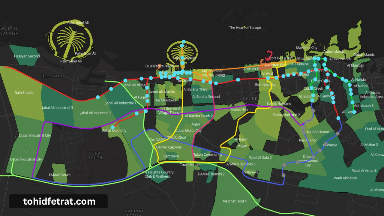
The Dubai Metro Blue Line is visualized on the Dubai Map, showing its confirmed Y-shaped route, all 14 planned stations, both branches, and the interchange points where it will meet the existing network. The map also includes the Red Line, the Green Line, the approved fully underground Gold Line, the Dubai Tram, and the Palm Monorail in one unified view.
Follow the route to see where the Blue Line meets the Green Line at Creek in Al Jaddaf and the Red Line at Centrepoint in Al Rashidiya, and which emerging communities sit within reach of each planned station before you shortlist an area.
Dubai's rail story now reaches beyond the metro too: the Etihad Rail network opens its Dubai passenger station at Jumeirah Golf Estates on 30 September 2026 with nol ticketing integration already agreed, and the planned Abu Dhabi to Dubai high speed line is reported to terminate at Al Jaddaf near Dubai Creek, placing its future terminus close to the Blue Line's Creek interchange.
Connections
Where the Blue Line will meet the rest of Dubai's rail network when it opens. Each interchange puts the surrounding district on two corridors at once.
Northern terminus and Green Line interchange in Al Jaddaf, linking the Blue Line to Deira, Bur Dubai, and the Creek districts.
Green LineSouthern terminus and Red Line interchange in Al Rashidiya, connecting the branch to the airport corridor and Sheikh Zayed Road.
Red LineThe Y-junction where the Creek and Centrepoint branches merge before the line continues as one spine to Academic City.
Blue Line junctionWhy It Matters
The Blue Line brings rail access to a swathe of eastern Dubai for the first time. Three things worth checking on the map before you shortlist a community.
Communities such as Dubai Silicon Oasis, International City, and Al Warqa sit on the confirmed alignment, letting buyers position ahead of the 2029 opening before rail connectivity is fully priced in.
Creek and Centrepoint will place their districts on two lines at once, the kind of dual connectivity that has historically supported tenant demand and resale liquidity around Union and BurJuman.
The line is planned to bring Dubai Creek Harbour and the Festival City corridor onto the metro for the first time, adding rail access to areas that currently rely on road links alone.
Explore the Network
The Blue Line is the newest part of a growing rail network. Explore every line across the system, from the operating metro lines to the tram and monorail, all visible on the Dubai Map.
The network backbone along Sheikh Zayed Road, which the Blue Line will meet at Centrepoint in Al Rashidiya.
Explore the Dubai Metro Red LineServes historic Deira and Bur Dubai, and will meet the Blue Line at Creek station in Al Jaddaf.
Explore the Dubai Metro Green LineDubai's first fully underground metro line, approved in 2026 to run 42 km from Al Ghubaiba to Jumeirah Golf Estates with 18 stations.
Explore the Dubai Metro Gold LineStreet level system serving Dubai Marina, JBR, and Al Sufouh, linked to the Red Line at DMCC and Sobha Realty.
Explore the Dubai TramRuns the length of Palm Jumeirah from the Gateway to Atlantis, linked to the Dubai Tram near the trunk of the island.
Explore the Palm Jumeirah MonorailThe line covered on this page, a Y-shaped route now under construction and targeted to open in 2029.
See the Blue Line on the Dubai MapFAQ
The Dubai Metro Blue Line is the metro network's third line, a 30 kilometer expansion approved in 2023 and now under construction. It is designed as a Y-shaped route connecting emerging residential, commercial, and education districts in eastern Dubai to the existing Red and Green Lines.
The Blue Line is targeted to open on 9 September 2029, coinciding with the 20th anniversary of the Dubai Metro, following construction, system installation, testing, and commissioning by the RTA.
The Blue Line will have 14 stations, with 9 elevated and 5 underground across its two branches. Several key station locations are confirmed, while the final names of a few stations are expected to be announced by the RTA closer to opening.
The Blue Line is a Y-shaped route with two branches. One branch runs from Creek in Al Jaddaf through Dubai Festival City, Dubai Creek Harbour, and Ras Al Khor, while the second runs from Centrepoint in Al Rashidiya through Mirdif and Al Warqa. Both branches meet at International City 1 before continuing to Dubai Silicon Oasis and Academic City.
The Blue Line will connect to the Green Line at Creek station and the Red Line at Centrepoint station in Al Rashidiya, allowing seamless transfers across Dubai's three metro lines and direct access to the airport and central business districts.
The Blue Line will serve nine key districts including Al Jaddaf, Dubai Festival City, Dubai Creek Harbour, Ras Al Khor, International City, Dubai Silicon Oasis, Academic City, Al Warqa, and Mirdif, connecting around one million residents to the wider metro network.
The Blue Line will be approximately 30 kilometers long, made up of about 15.5 kilometers of underground track and 14.5 kilometers of elevated track, and will include the first Dubai Metro crossing over Dubai Creek.
Yes. The Blue Line will operate as a fully automated, driverless metro system, consistent with the existing technology and operational standards used on the Red and Green Lines.
Yes. The confirmed Blue Line alignment, both branches, and its interchange points are shown on the Dubai Map on this page, alongside the Red Line, Green Line, Dubai Tram, and Palm Monorail.
The Blue Line brings metro access to fast-growing eastern districts for the first time. Communities near confirmed station locations and the twin-line interchanges at Creek and Centrepoint are positioned to benefit from improved connectivity as the 2029 opening approaches, similar to patterns seen around existing metro corridors.
No direct interchange between the Blue Line and the Gold Line has been announced. The Gold Line, approved in April 2026 and planned to open in 2032, will meet the Red Line at Business Bay and Jumeirah Golf Estates and the Green Line at Al Ghubaiba, so passengers will transfer between the two lines via the Red or Green Line. Together the Blue and Gold Lines expand the metro network from 120 to 162 kilometers and from 67 to 85 stations.

Tohid Fetrat
Dubai Real Estate Advisor
The Opus by Omniyat, Business Bay