Red Line
OperatingThe backbone of the network, running along Sheikh Zayed Road and linking the airport with Dubai Marina, Downtown, Business Bay, and Expo City.
Explore the Dubai Metro Red Line
Dubai Public Transport
Every metro line, station, and interchange across Dubai, mapped in one place so you can see exactly which communities and projects sit on the network.
90 km
Metro network operating today
55
Metro stations in service
162 km
Planned network by 2032
295M
Metro passengers in 2025
Dubai Metro Lines
Two metro lines run today, two more are approved through 2032, and the tram and monorail complete the picture. Every route is visible on the Dubai Map.
The backbone of the network, running along Sheikh Zayed Road and linking the airport with Dubai Marina, Downtown, Business Bay, and Expo City.
Explore the Dubai Metro Red LineServes historic Dubai and the city's densest districts, connecting Deira, Bur Dubai, and the Creek with two Red Line interchange stations.
Explore the Dubai Metro Green LineA 30 km line with 14 stations now under construction, opening 9 September 2029 and serving Dubai's eastern residential corridors.
Explore the Dubai Metro Blue LineA street level system serving Dubai Marina, JBR, and Al Sufouh, linked to the Red Line and the Palm Monorail through direct interchanges.
Explore the Dubai TramDubai's first fully underground line, 42 km with 18 stations, approved in April 2026 and scheduled to open 9 September 2032.
Explore the Dubai Metro Gold LineA 5.5 km elevated line along the trunk of Palm Jumeirah, running from Palm Gateway to Atlantis Aquaventure across four stations.
Explore the Palm Jumeirah MonorailNetwork
Every rail system in Dubai side by side, including the two lines approved but not yet open, so you can see what runs today and what is coming.
| System | Status | Length | Stations | Opened / Opening |
|---|---|---|---|---|
| Metro Red Line | Operating | 52 km plus 15 km branch | 35 | September 2009 |
| Metro Green Line | Operating | 23 km | 20 | September 2011 |
| Dubai Tram | Operating | 10.6 km | 11 | November 2014 |
| Palm Monorail | Operating | 5.5 km | 4 | April 2009 |
| Metro Blue Line | Under construction | 30 km | 14 | 9 September 2029 |
| Metro Gold Line | Approved | 42 km fully underground | 18 | 9 September 2032 |
| Metro network by 2032 | Four lines | 162 km | 85 | Up from 90 km today |
The Gold Line will expand the metro network by 35 percent and carries an investment of about AED 34 billion ≈ USD 9.3 billion. The Blue Line contract was awarded at AED 20.5 billion ≈ USD 5.6 billion.
Timeline
Seventeen years of rail expansion in Dubai, from the first driverless line to the fully underground route approved for 2032.
April 2009
The first monorail in the Middle East begins running along the trunk of Palm Jumeirah between Palm Gateway and Atlantis.
September 2009
Dubai Metro opens on 9 September 2009 as the first rapid transit network in the Gulf, running along the Sheikh Zayed Road corridor.
September 2011
The second line opens through Deira and Bur Dubai, creating the Union and BurJuman interchanges that still anchor the system.
November 2014
Street level rail arrives in Dubai Marina, JBR, and Al Sufouh, linking the Red Line to the Palm Monorail at Palm Gateway.
2021
A 15 km branch with seven stations opens toward Expo City, pulling the network into Dubai's southern growth corridor.
2029 target
Fourteen stations across 30 km, targeted for 9 September 2029, exactly twenty years after the metro first ran. Tunnelling began in 2026.
2032 target
Approved in April 2026 and scheduled for 9 September 2032, the 42 km underground route takes the network to 162 km and 85 stations.
Dubai Map
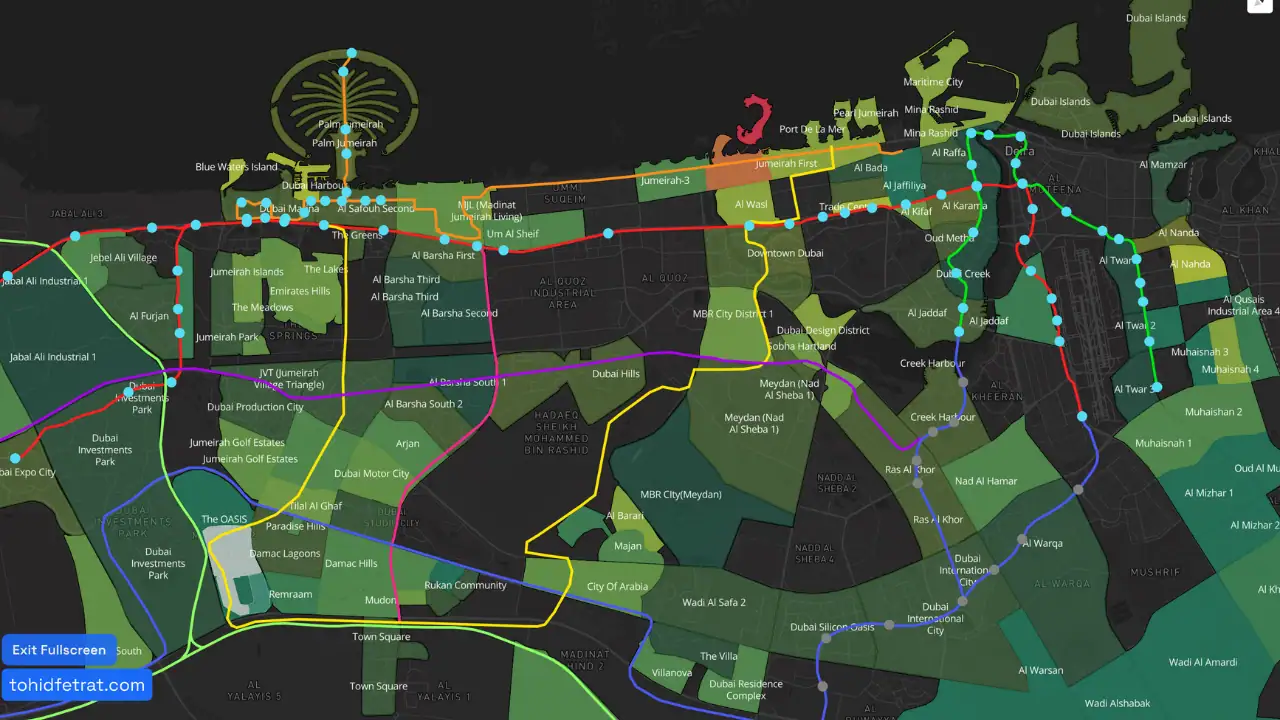
The full rail network is visualized on the Dubai Map in one unified view, including the operating Red Line and Green Line, the under construction Blue Line, the approved Gold Line, the Dubai Tram, and the Palm Monorail.
Follow each route across the city to see where the lines interchange, where the 2029 and 2032 expansions will add stations, and which residential and commercial communities sit within reach of each line before you shortlist an area.
Communities
A quick read on where each line puts you, based on the routes published by the RTA and the Government of Dubai Media Office.
The Sheikh Zayed Road spine, linking the airport with the central business and waterfront districts.
Historic Dubai and the Creek, covering the densest established residential districts in the city.
Eastern Dubai, connecting large residential and academic districts that rely on cars today.
An underground route bridging the historic centre with the newer inland master communities.
Essentials
The basics for anyone viewing property along the network, from how the system operates to how far it reaches.
Dubai Metro is fully automated and driverless, with a top operating speed of 95 km/h. Stations and trains are accessible for People of Determination.
Travel across the metro, tram, and buses runs on the nol card, with fares calculated by the number of zones crossed. Buy or top up at any station.
Services run daily with a later start on Sundays and extended hours on Fridays. Check the RTA timetable before travelling, since hours change on holidays.
Union and BurJuman connect the Red and Green Lines. Sobha Realty and DMCC connect the Red Line to the tram, which reaches the monorail at Palm Gateway.
The metro carried 295 million passengers in 2025, around a million a day, and accounts for roughly 40 percent of all public transport journeys in Dubai.
The RTA has stated that the Gold Line is expected to lift property values near its stations by up to 20 percent as the route is delivered.
Why It Matters
Transport connectivity shapes how districts perform. Three things worth checking on the map before you shortlist a community.
Communities within walking distance of a station tend to attract steadier tenant demand, which supports occupancy and long term rental performance.
Districts around interchange stations sit on two corridors at once, giving residents faster access across the city in every direction.
Areas along announced routes such as the Blue Line often reprice as construction advances, so early awareness of the alignment can matter.
FAQs
Dubai Metro operates two lines today, the Red Line and the Green Line. The Blue Line is under construction for 2029 and the Gold Line was approved in 2026 for 2032, taking the network to four lines.
Yes. All existing metro lines, stations, interchanges, future metro lines, and the Dubai Tram are visible on the Dubai Map on this page.
Each metro line serves different corridors of the city. The Red Line connects major business and airport districts, the Green Line serves historic and high density areas, and the future Blue Line will improve east west connectivity.
Yes. Dubai Metro is a fully automated, driverless rail system designed for high efficiency, safety, and reliability.
Yes. The Dubai Map highlights metro stations alongside nearby communities, allowing you to explore residential and commercial areas connected to the metro network.
Yes. Dubai Metro connects with the Dubai Tram, Palm Monorail, and other public transport systems through designated interchange stations.
The Gold Line is a 42 km fully underground metro line with 18 stations, approved in April 2026 and scheduled to open on 9 September 2032. It will run from Al Ghubaiba to Jumeirah Golf Estates and expand the network by 35 percent.
The Blue Line is targeted to begin operations on 9 September 2029, twenty years after the metro first ran. It covers 30 km with 14 stations and is currently under construction.
The monorail runs 5.5 km along Palm Jumeirah between Palm Gateway and Atlantis Aquaventure. Palm Gateway is reachable from the Dubai Tram, which in turn connects to the Red Line at Sobha Realty and DMCC.

Tohid Fetrat
Dubai Real Estate Advisor
The Opus by Omniyat, Business Bay