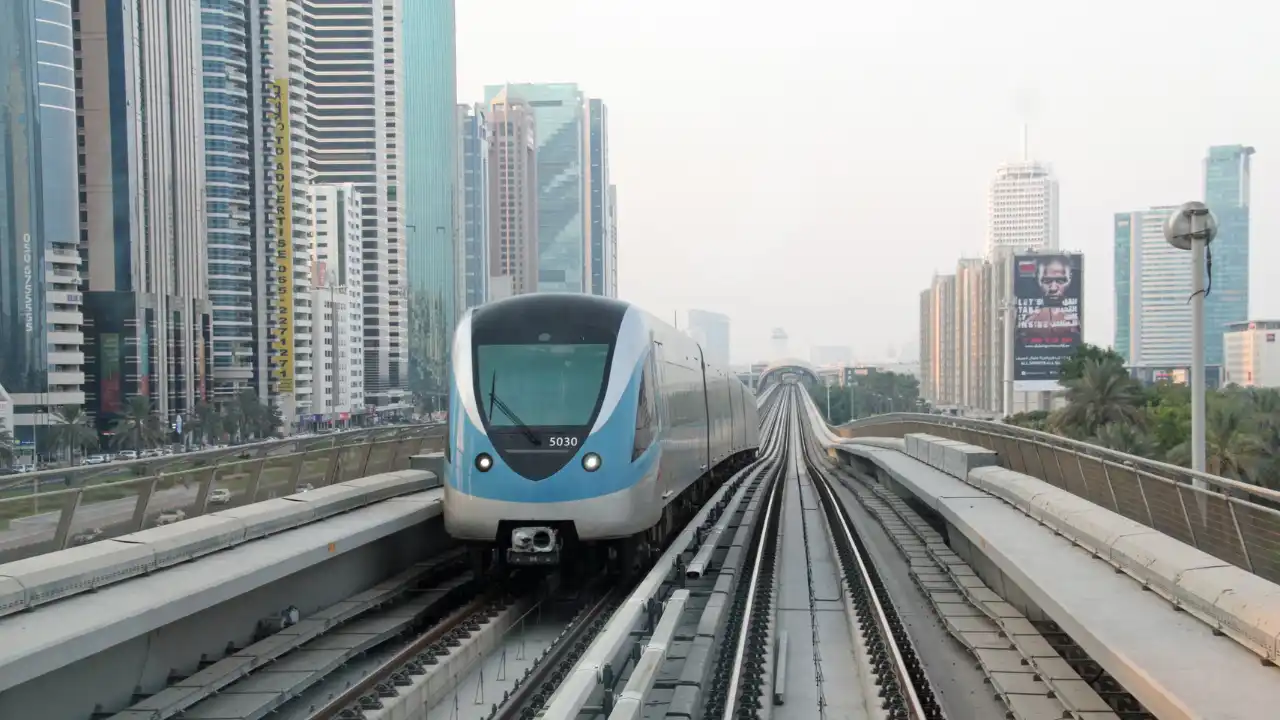
The Dubai Metro Red Line is the main east–west metro corridor in Dubai, connecting Dubai International Airport with major business districts, residential areas, Jebel Ali, and Expo City Dubai through a fully automated, driverless rail system.
- Home
- Dubai Map
- Projects
- Emaar Projects
- Palace Residences Hillside
- Creek Haven
- Avarra By Palace
- Salva at The Heights
- Serro at The Heights
- Serro2 at The Heights
- Emaar Beachfront new launch 2026
- Emaar Beachfront Apartments For Sale
- Bayview by Address Resorts
- SeaPoint at Emaar Beachfront
- Rashid Yachts & Marina apartments for sale
- the valley townhouses and villas for sale
- Sera 2 at Rashid Yachts & Marina
- Farm Grove 2 at The Valley
- Fior 1 at Rashid Yachts & Marina
- Aurea at Rashid Yachts & Marina
- Elora at The Valley
- Damac Projects
- Nakheel Projects
- Omniyat Projects
- Binghatti Projects
- Meraas Projects
- Beyond Projects
- Sobha Projects
- Ellington Projects
- IRTH Projects
- Imtiaz Projects
- Emaar Projects
- Developers
- Areas & Communities
- Dubai Hills Estate
- Palm jebel ali
- Palm Jumeirah
- Downtown Dubai
- Business Bay
- Dubai Marina
- Dubai Islands
- THE OASIS
- Emaar Beachfront
- Dubai Design District (d3)
- Island A
- Island B
- Island E
- Nad Al Sheba Gardens
- Grand Polo
- DAMAC Island 2
- The Heights Country Club & Wellness
- Binghatti City – Mercedes Benz Places
- Dubai Creek Harbour
- The Meriva Collection
- Jumeirah Village Circle (JVC)
- Sobha Elwood
- SIORA
- Tilal Binghatti
- Dubai Maritime City
- Dubai Harbour
- Rashid Yachts & Marina (Mina Rashid)
- Palm Central
- The Valley by Emaar
- New Launches
- Guides
- Tohid Fetrat
- English
Dubai Metro Red Line | Stations, Route Map, History & Future Expansion
Explore the Dubai Metro Red Line on the Dubai Map. View stations, routes, Expo City extension, Blue Line connections, travel times, and how the Red Line connects key areas across Dubai.
History of the Dubai Metro Red Line
The Dubai Metro Red Line was conceived in the early 2000s as part of Dubai’s long-term urban mobility vision to reduce road congestion and support rapid economic and population growth. Construction began in 2006, marking the UAE’s first large-scale rail transit project and one of the world’s earliest fully automated, driverless metro systems. The Red Line officially opened on 9 September 2009, initially serving key corridors along Sheikh Zayed Road. By April 2010, the full core route was operational, connecting Dubai International Airport with major business districts, residential areas, and emerging urban zones across the city. The introduction of the Green Line in 2011 established interchange stations at Union and BurJuman, reinforcing the Red Line as the backbone of Dubai’s metro network. A major milestone came with the Route 2020 extension, launched to support Expo 2020 Dubai, which extended the Red Line from Jabal Ali to Expo City Dubai and opened in 2021. Today, the Red Line continues to evolve through service optimizations and future integration with the upcoming Blue Line, securing its role as Dubai’s primary east–west transit corridor and a key driver of urban development.
Dubai Metro Red Line on the Dubai Map
The Dubai Metro Red Line is fully visualized on the Dubai Map, showing its complete route, all stations, interchange points, and direct connections across the city. The map includes existing metro lines, the future Blue Line, Dubai Tram, and the Palm Monorail, providing a unified view of Dubai’s present and planned rail network.
Using the Dubai Map, you can clearly see how the Red Line intersects with the upcoming Blue Line at key interchange stations, strengthening east–west connectivity and linking historic districts with emerging urban zones. This integrated layout helps illustrate how Dubai’s rail infrastructure works as a single system, supporting mobility, urban growth, and long-term development across the city.
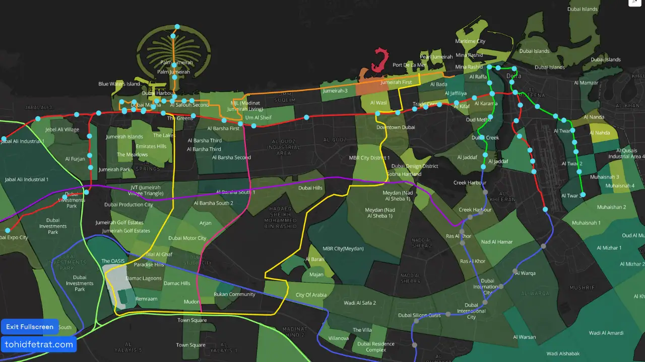
Click to view Dubai interactive map
Dubai Metro Red Line in Numbers
Opening Year
2009
Total Line Length
approx. 67 km
Total Stations
35 stations
Main Line + Branches
2 branches (Life Pharmacy & Expo City)
Key Interchange Stations
5+ (Union, BurJuman, Jabal Ali, DMCC, Sobha Realty)
Travel Time (End to End)
approx. 65–75 minutes (Centrepoint to Life Pharmacy / Expo City)
Train Type
Fully automated, driverless metro
Maximum Operating Speed
up to 95 km/h
Peak Frequency
as low as 2.5 minutes during peak hours
Daily Ridership (Network Share)
part of a metro system serving 700,000–900,000 passengers per day
Major Extension
Route 2020 to Expo City (opened 2021)
Future Integration
Direct interchange with the upcoming Blue Line
Frequently Asked Questions About the Dubai Metro Red Line
What is the Dubai Metro Red Line?
How long is the Dubai Metro Red Line?
The Red Line is approximately 67 kilometers long, making it the longest metro line in Dubai and one of the longest driverless metro lines in the world.
How many stations are on the Dubai Metro Red Line?
The Dubai Metro Red Line has 35 stations, including interchange stations with the Green Line, Dubai Tram, Route 2020, and future connections to the Blue Line.
Which areas does the Red Line connect?
The Red Line connects key areas such as Dubai International Airport, Deira, Bur Dubai, Downtown Dubai, Business Bay, Dubai Marina, Jebel Ali, and Expo City Dubai.
Why is the Dubai Metro Red Line important for urban development?
The Red Line supports Dubai’s long-term urban growth by improving mobility, reducing road congestion, and enabling transit-oriented development across major business and residential corridors.
What is Route 2020 on the Red Line?
Route 2020 is an extension of the Red Line that branches from Jabal Ali and connects directly to Expo City Dubai. It opened in 2021 and serves several residential and investment-focused communities along the corridor.
How does the Red Line connect with the Blue Line?
The Dubai Metro Blue Line will connect with the Red Line at Centrepoint station. This interchange and the full connection can be clearly viewed on the Dubai Map on this page.
Can I see all Red Line stations on the Dubai Map?
Yes. All Dubai Metro Red Line stations, branches, interchanges, and connections are fully visible on the Dubai Map, alongside other metro lines, tram routes, and the Palm Monorail.
Is the Dubai Metro Red Line fully automated?
Yes. The Red Line operates as a fully automated, driverless metro system, with onboard staff present for passenger assistance and safety.
How long does it take to travel the full Red Line?
End-to-end travel time on the Red Line typically ranges between 65 and 75 minutes, depending on the destination branch and service pattern.
Dubai Metro Lines
Explore all of Dubai’s Metro lines in one place. Whether you’re looking into the Green, Red, Blue, or future lines, this section will guide you through each route and their connections.
Loading…
Dubai Real Estate Projects
Explore Dubai's luxury and premium real estate projects, complete with detailed brochures, sizes, and all the information you need in one convenient place.
Loading…
Dubai Real Estate Areas & Communities
Explore Dubai’s most sought-after areas and communities. Discover the unique character, lifestyle, and amenities that each neighborhood offers
Loading…
Dubai Real Estate developers
Meet the visionary developers shaping Dubai's skyline. Explore profiles of top developers, their signature projects, and their contributions to the city’s luxury real estate landscape.
Loading…

For any questions about your real estate investment, message or call me directly. I’m here to guide you toward the best opportunities in Dubai.
Tohid Fetrat
This website uses cookies to ensure you get the best experience on our website.
Let’s build your Dubai portfolio together
+971 543 443 597
Latest News

- Privacy Policy
- Terms & Conditions
- Customer Policy.
Copyrights © 2025 Tohid Fetrat